As Trilby has been getting older, I realized I have a diminishing window to take her on one last big backpacking trip. I picked the Bartram Trail because it’s long enough to require some good planning but not multi-week like the BMT, Pinhoti, or god forbid, the AT. Unfortunately, we had to stop halfway. The trip report will tell the story and lessons learned, followed by the planning doc. I’m not good about taking photos and my hiking tends to be about knocking out miles so I don’t have a lot of lovely details to report.
Trip Report
Day 1 – Russell Bridge to Martin Creek (20.6 miles)
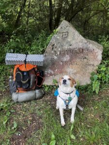
I left Chattanooga at around 3:45am so I could start the hike around 7am. Russell Bridge–the southern terminus–is right at the Georgia/South Carolina border, crossing the Chattooga River. It was a beautifully cool morning, but got hot really quickly once the sun came up over the mountains.
The first few miles follow the river and thus are flat and fast, and we hiked them accordingly. Said hi to a trio of fishermen trying for trout. Eventually the trail left the river and started climbing. That’s when I pulled out the trekking poles. There was a slight mishap around mile 6 where I blew right past a blaze and kept going straight on a service road. My spidey sense warned me something was wrong so after checking CalTopo, I figured out the problem. The blaze I missed happened to be very high above head height. Thankfully I believe I only added in about 1/3 mile extra in course correction.
We had lunch around mile 12 at a dry campsite on a ridge. I was carrying a small stuffed animal (11g weight) that reminds me of John and was taking photos with it posed as if it were doing things. Because of this, at some point right after lunch I realized that it had fallen out of my pocket. Cue the meltdown. But at least I had the wherewithal while ugly crying to post in the Bartram Trail Hikers Facebook group asking people to look for it with approximate location and then to call a friend who talked me off the ledge. All this while still hiking because we had miles to go.
The rest of the day was relatively uneventful until I got to Warwoman Dell, around mile 19.4. I stopped to chat with a nice woman who retired from life to live out of her van. Then at the intersection of Becky Branch and the Bartram, in the middle of nowhere, I saw a car camping tent set up with a guy shirtless sitting in it. I asked him which direction he was going and he didn’t understand my question. I expressed concern that he had no water there and said he should head to Warwoman Dell. Something about him seemed off so when he asked about the direction I was going, I said there wasn’t much that way. I thought that was it. Met a southbound thru hiker and asked him to look for my stuffed animal. He said he had seen my post and would look for it.
I got to the Martin Creek campsite and it was absolutely lovely, a wide open area right by the fast flowing creek. Set everything up and was making dinner when the guy with the car camping tent appeared bringing bags of gear loaded onto an electric scooter (the push kind, not Vespa kind). I felt a flash of annoyance and then worry because this was NOT normal behavior. But he set up his tent far from me so I didn’t think anything about it. Crawled into my tent around 6pm and all of sudden he’s talking to himself about conspiracies and other weird things. I started getting scared but both Trilby and I were exhausted and had no energy to pack up and go. In retrospect, we should have anyway. Around 11pm he shined his flashlight into my tent asking if anyone was in there (what???) and when I told him to go away he asked if I had someone in there with me. I immediately lied and said yes and that we were trying to sleep. He apologized and that was the last I heard from him. I barely slept, waiting for something to happen. At 5:30am when I opened my tent he was sitting right outside and I yelled at him to get away from me. He went back to his tent and I immediately started packing stuff in the dark. As soon as it was light I glanced over out of the corner of my eye and saw that his tent was open and he was obviously masturbating. And so I immediately slammed everything into my pack and left before anything worse happened. Thankfully, that was the last I saw of him.
For the record, this is the first time in years and years of solo backpacking that something even remotely like this has happened.
Day 2 – Martin Creek to West Fork Creek Overflow (19.7 miles)
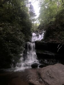
Though shaken from the night’s experience, the miles had to be hiked so off I went. Passed by the lovely Martin Creek Falls immediately after camp and then started a lot of climbing. It started raining about an hour into the day, though I stayed dry thanks to my raincoat and rain skirt. We ate lunch around mile 9, 3 miles before Rabun Bald, because all the climbing was making me so hungry. Unfortunately, by this point Trilby was starting to lose her appetite. This happens on occasion with her and lately it’s been happening at home too, but with so many miles to go on this trip I was getting worried. Tried to tempt her with bits of my food but no luck. And speaking of, that lunch was the last time I was hungry either.
Around mile 12.5 we reached Rabun Bald, the second tallest mountain in Georgia. It was breathtaking with all the fog nestled in the valleys in all directions. I immediately called John to share my joy (and also needed to hear his voice after the previous night). Unfortunately, I was so discombobulated that I didn’t take any photos of the view, just one selfie and the USGS survey marker for John.
Honestly, I don’t remember most of the day, just that it felt easier than the first thanks to the cooler weather. I crossed the Georgia/North Carolina line around 2pm right past Hale Ridge Rd. The plan was to camp somewhere between there and the West Fork Overflow Creek; since I felt great I just went all the way to the creek where there was a lovely little campsite. Spent a peaceful night alone which was a relief after the scare from the night before and exactly why I come to the backcountry when I can. Still was concerned about Trilby’s lack of appetite but not really mine.
Day 3 – West Fork Creek Overflow to Hickory Knoll Trailhead, sorta (15.8 miles)
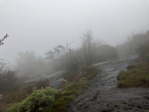
A deep, 11 hour sleep refreshed me and Trilby which was great because the trail went up, up, up first to Osage Overlook and then on to Scaly Mountain. This was a ridge of open rock and gnarled trees, absolutely gorgeous in the morning fog.
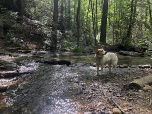
We hiked along the ridge gradually descending before dropping steeply into the beautiful Tessentee Creek camping area and snack time. The climb out of the creek was brutal though. I don’t do heights well and there were a couple narrow rocky areas with a steep, very long dropoff with a great view of just how far I’d fall if I slipped. Fought off several panic attacks but made it through fine. Eventually we got to more open terrain and, yay, more climbing!
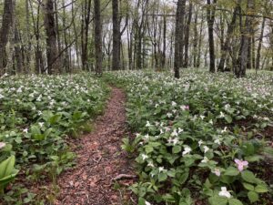
I was in a hurry and setting an even more aggressive pace than the previous days knowing we’d be seeing John at the trailhead for a rest day together but by this point Trilby was starting to fall behind due to not eating. Eventually I took her pack from her so she didn’t have to carry even its empty weight, which seemed to help a bit. Little climbs along a ridgeline brought us to Keith Day Knob and a gorgeous field of flowers before taking us to Jones Gap.
At this point I was worried sick about Trilby and in a hurry to get to John so I hauled ass for the rest of the trail. Most of it was downhill, which sounds great in theory but a lot of it was steep enough that I had to use my poles to control the forward momentum and there were many steep switchbacks I had to pick my way down.
Finally I got to an intersection that said Hickory Knoll 3.7 miles, Buckeye Creek 2.3. I was confused because the guide said the trail hit the road at Hickory Knoll and that’s where I knew John would be but my CalTopo map showed the path going down Buckeye Creek. Thankfully I had cell service and rerouted him to Buckeye Creek because I was just NOT going to do an extra 1.4 miles at that point.
It was a cranky reunion: John was exhausted from the long drive from Chattanooga and confused about the reroute, and I was exhausted from the trail. Eventually we got over ourselves, went to the grocery store for food, and then off to my friend’s cabin in Franklin for the night. I ate a bit but still had no appetite and when I actually looked at myself, I was noticeably thinner. Trilby was absolutely dead on her feet from 2 days of almost no food. At some point I woke up in the night and realized I just didn’t want to go on farther. I laid in bed struggling with the thought that I would be abandoning my hike but it just wasn’t worth it. My body felt fine but the obvious depletion on both my and Trilby’s part meant that the next 3 days of even harder hiking would start becoming dangerous if we couldn’t eat. I missed John so terribly too. And I still didn’t feel ok about what happened that first night. So in the morning we packed up and headed home.
On the way to get my car from the trailhead I got a message on Facebook from a guy who found the little stuffed animal! He said he would send it to me and when I asked for his Venmo/PayPal to send him shipping costs he said not to worry about it. So I paid it forward by buying a donut for some AT thru hikers taking a break at the Dunkin’ Donuts in Hiwassee on the way home, and will be donating extra to the Bartram Trail Conservancy in this guy’s honor.
Lessons Learned
I really need to figure out what to do about my caloric intake. According to a calorie calculator, I needed about 4,000 calories per day. Due to weight and pack size limits, I could reasonably only carry about 3,000 per day and since I lost my appetite was likely eating closer to 2,500. On my normal 1-2 night trips this isn’t an issue but with what was to come, there was no way I could sustain this. I don’t know whether I need to find more calorically dense yet palatable foods or just do fewer miles per day. I was already taking as much fat as possible via nuts and oils but it still wasn’t enough.
My pack was really heavy: starting at 25.4 lbs. I had to carry all of Trilby’s food and a bear canister which, in total, added over 5 lbs to the weight. I don’t trust my ability to do a bear hang and I wasn’t sure if there would even be the right setup to do one. The bear poop I saw on the trail reassured me I was right to carry the can. I also always carry 2L water because I sweat a LOT and in dry stretches have to water Trilby too; I needed all that water in some areas. I didn’t finish putting together my Pack Wizard list so I can’t link it here but I used almost every piece of equipment I took, and my 20F bag was perfect despite the high 50s night temperature, so I don’t know what I could reduce. But still, this is 20% of my body weight and that’s a LOT.
Speaking of bear cans, my trail buddy Steve recommended some reflective tape that he put on his can and it worked perfectly. In the pre-dawn darkness, it was easily visible. There’s a strip on the lid, bottom, and two wrapped around so if a bear does roll it around I can find it no matter how it ends up.
Even with all that weight I felt fine despite the caloric deficit. I had only one tiny blister despite wet feet for two days. The one tick that started to embed, I pulled out before it got really in; I’m sure my permethrin soaked clothes helped a lot. Next trip I’ll also treat Trilby’s collar and pack.
I wish I had done this trip with Trilby a few years ago when she was more spry. At 9 years old I knew this was my last chance to do a long trip with her but evidently that window was already closed. It’s killing me knowing my little girl is getting older.
As for the creep at the first night’s camp, I should have listened to my gut and left even if it meant hiking extra or even ending the trip. I’m well aware that I got lucky that no sexual assault or worse happened. It will in no way stop me from backpacking solo, nor will I carry a weapon because I don’t train to use one in surprise situations like that middle of the night awakening and it’s more likely to get used against me. Unfortunately this is the reality that women face when doing activities that men don’t think twice about.
A day later, back home, I have zero regrets about abandoning the hike. I got what I wanted out of the trip: isolation, time with Trilby, some nice physical challenges. Most of all, I learned that there’s finally something in my life that is more important to me than being on my own, and that’s being with John.
Planning Doc
This is my standard format planning doc with personal info removed. I create one on Google Docs for every multi-night backpacking trip and share it with my emergency contacts.
Route: Bartram Trail northbound from Russell Bridge, GA to Cheoah Bald, NC
Length: About 112 miles (minus 10 miles for road section)
Duration: 6 days, 5 nights not including rest days
Daily Itinerary
AllTrails with waypoints including road access links
CalTopo with waypoints
| Date | Mile Marker | Miles | Total Miles | Campsite | Road Access | |
|---|---|---|---|---|---|---|
| 1 | 2024-05-02 | GA 20.6 | 20.6 | 20.6 | Martin Creek | Warwoman Dell (go north on trail) |
| 2 | 2024-05-03 | NC 3.0 | 18-19 | 38.6-39.6 | Flat ridge with campsites | Hale Ridge Rd (go north on trail about 2-3 miles) |
| 3 | 2024-05-04 | NC 20.4 (1) | 17.5 | 56.9 | Cabin with John | Hickory Knoll Rd (will be heading north to here) |
| 2024-05-05 | — | – | REST DAY | Return to trail at Wallace Branch | ||
| 4 | 2024-05-06 | NC 20.7 (2) | 20.7 | 77.6 | Nantahala Lake (north side) | Nantahala Dam Rd @ High Water Trail |
| 5 | 2024-05-07 | NC 36.3 (2) | 15.6 | 93.2 | Ledbetter Creek | Hwy 19 @ 1 mile north of Nantahala River Launch Site (downstream towards NOC) |
| 6 | 2024-05-08 | Summit and back | 9.8 | 103 | Shuttle pickup to car | Nantahala River Launch Site (kayak put in) |
Tracking
<Link to my inReach tracking page was here>
I’ll be using a Garmin inReach Mini. Waypoints will be added every 2-4 hours during hiking time to conserve battery life except when approaching a resupply point, when they will be more frequent (up to every 10 minutes).
Contacting Me
I’ll have my cell phone on me in airplane mode or off to conserve battery. In addition, much of the trip will be out of cell service. To guarantee reaching me, follow the relevant instructions here. Note that I pay $0.50 per message so please don’t text unless it has something to do with trip logistics. Yes, I miss you too.
Contacting You
I will be contacting John daily and any other backup as necessary to confirm meetups. Contact him for more details about my trip.
Shuttle Return to Start
I will be picked up at 1pm on May 8 at the Nantahala River Boat Launch Site by the following shuttle service that will take me back to my car at Russell Bridge:
Michelle @ White Blaze Shuttle Service
(706) 300-8964
Personal/Medical Information
In case you need to give to EMS or other first responders
Full name: Karen Ziv
DOB: <my DOB>
Age: <my age>
Height: <my height>
Weight: <my weight>
Hair: <description of hair length and color>
Eyes: <eye color>
Allergies
- Minor allergies with reactions
- Major allergies – allergy shots have this under control but I carry two epipens
Blood type: <blood type>
Organ donor
DNR
Traveling with a 30lb spayed female cattle dog mix, white with brown spots. Dog is friendly, microchipped and will be wearing a collar with her tags.
Car parked at Russell Bridge:
Make and model: <make and model of car>
Color: <car color>
License: <license plate number>
Emergency Contacts
<Contact 1 Name>
City, ST
(123) 555-1212
<Contact 2 Name>
City, ST
(123) 555-1212
<Contact 3 Name>
City, ST
(123) 555-1212
Friend’s Cabin
We will be staying at my friend <friend’s full name>’s cabin in Franklin over the weekend.
Address: <address>
<Directions and info about the cabin>
Resources
Bartram Trail Hikers Facebook Group – https://www.facebook.com/groups/1414749585430675
Detailed trail descriptions with mile markers – https://www.trailquest.net/BRbartram.html
Hiking Project routes
- South of Franklin, NC – https://www.hikingproject.com/trail/7063378/bartram-trail-164-south
- North of Franklin, NC – https://www.hikingproject.com/trail/7063308/bartram-trail-164-north
Blue Ridge Bartram Trail Conservancy (no useful info for emergency contacts) – https://blueridgebartram.org/
Georgia Bartram Trail Group (no useful info for emergency contacts) – https://gabartramtrail.org/